|
|
Upper Duck River Watershed (including Normandy Reservoir)
"The Upper Duck River watershed is located in Middle Tennessee, south of Nashville. It is made up of cropland, pasture, hayland, and forestland. Seventy-two percent of the watershed is cropland and pastureland. Croplands consist of cotton, corn, soybeans, hay, grain sorghum, nursery crops, and wheat. There are approximately 3,745 farms in the watershed.
"Conservation practices used on cropland include terraces, grade control structures, waterways, diversions, contour farming, field borders, crop rotation, water and sediment control basins, conservation tillage, winter cover crops, and cropland conversion to permanent vegetation.
"The Upper Duck watershed has a growing poultry industry in Bedford County, as well as a developing nursery industry in Coffee County. The Maury County portion of the Upper Duck is a rapidly developing urban area and has been designated a Scenic River. The watershed is home to 22 aquatic threatened and endangered species listed (either State or Federal)."
Land Cover/Use
|
Land Use |
Acres |
|
Cropland |
147,482 |
|
Hayland |
101,491 |
|
Pastureland |
155,127 |
(Reference: United States Department of Agriculture, Natural Resources Conservation Service. Upper Duck River Watershed. Available on the World Wide Web at http://www.tn.nrcs.usda.gov/programs/CSP/upper_duck_river_watershed.html>.)
HUC Code: TN06040002
Counties: Bedford, Coffee, Marshall, and Williamson
Ecoregions: 71g, 71h, 71i
Drainage Area: 1,553 square miles
TDEC Stations: 282
TVA Stations: 8
Advisories: 2
Watershed Group: 3
|
Category Assessment |
Stream Miles |
Reservoir Acres |
Support Assessment |
|
Total Miles/Acres |
1,606.9 |
3,260 |
|
|
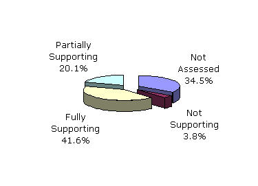
Assessed Miles/Acres |
1,052.9 |
3,260 |
|
|
Category 1 |
256.9 |
3,260 |
Fully Supporting (668.4 miles) (3,260 acres) |
|
Category 2 |
411.5 |
0 |
|
|
Category 3 |
554.0 |
0 |
Not Assessed |
|
Category 4a |
47.4 |
0 |
Partially Supporting (322.8 miles) Not Supporting (61.7 miles) |
|
Category 5 |
337.1 |
0 |
"The entire watershed is in Tennessee. Normandy Dam, built for flood control, is TVA's largest non-power generating dam. Over 1,000 stream miles have been assessed with the majority fully supporting. Pathogens, nutrients, siltation and habitat alteration from agricultural activities impair the most stream miles. Normandy Reservoir is fully supporting.
"A portion of the Duck River is designated as a State Scenic River. The river also provides habitat for several endangered species. Two high quality streams are subecoregion reference sites, Flat and Little Flat Creeks in 71i (Inner Nashville Basin)."
(Reference: Tennessee Department of Environment and Conservation. 2004 305(b) Report: The Status of Water Quality in Tennessee. Available on the World Wide Web at <http://www.state.tn.us/environment/wpc/publications/>.)