|
|
Lower Duck River Watershed
HUC Code: TN06040003
Counties: Dickson, Hickman, Humphreys, Lawrence, Lewis, Maury, Perry, Wayne, Williamson
Ecoregions: 71f, 71h
Drainage Area: 736 square miles
TDEC Stations: 153
TVA Stations: 14
Advisories: 0
Watershed Group: 3
|
Category Assessment |
Stream Miles |
Reservoir Acres |
Support Assessment |
|
Total Miles/Acres |
2,461.8 |
100,013 |
|
|
Assessed Miles/Acres |
1,458 |
100,000 |
|
|
Category 1 |
336.2 |
100,000 |
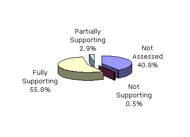
Fully Supporting (1,374.0 miles) (100,000 acres) |
|
Category 2 |
1,037.8 |
0 |
|
|
Category 3 |
1,003.8 |
13 |
Not Assessed |
|
Category 4a |
0 |
0 |
Partially Supporting (70.9 miles) Not Supporting (13.1 miles) |
|
Category 5 |
84 |
0 |
"The entire watershed is in Tennessee. The area is primarily agricultural with some small towns and industry. Point source discharges (industrial and municipal), urban runoff, abandoned mines and livestock operations are sources of impairment.
"This watershed has three high quality streams that are subecoregion reference sites, Wolf Creek, Little Swan Creek and Hurricane Creek in 71f (Western Highland Rim)."
(Reference: Tennessee Department of Environment and Conservation. 2004 305(b) Report: The Status of Water Quality in Tennessee. Available on the World Wide Web at <http://www.state.tn.us/environment/wpc/publications/>.)